
Machu Picchu Map: Where It Is in Peru and How the Ruins Are Laid Out
By the Goo Machu Picchu team · Checked against official sources (editorial policy) · Updated October 2026 · 6 min read
A Machu Picchu map answers two questions: where the citadel sits in Peru, and how the ruins are laid out. Machu Picchu lies in the southern Andes, about 47 miles (75 km) northwest of Cusco. The site splits into a farming sector in the south and an urban sector in the north, with Huayna Picchu beyond.
- Country and region
- Peru, Cusco Region, Urubamba Province
- Coordinates
- About 13.16° S, 72.55° W
- Elevation
- About 7,970 ft (2,430 m)
- From Cusco
- About 47 miles (75 km) northwest in a straight line
- Nearest town
- Aguas Calientes, in the valley below
- Site sectors
- Agricultural (south) and urban (north)
Where Is Machu Picchu on a Map of Peru?
On a map of Peru, Machu Picchu sits in the southern Andes, in the Cusco Region, on a ridge above the Urubamba River. It is roughly 310 miles (500 km) southeast of Lima and about 47 miles (75 km) northwest of Cusco. The citadel lies where the high Andes start to drop toward the Amazon rainforest.
In South America, Peru is on the Pacific coast between Ecuador, Colombia, Brazil, Bolivia and Chile. Machu Picchu is in the southern half of the country, closer to Bolivia than to Ecuador. No road reaches the site directly from Cusco, which is why most maps show a rail line ending at Aguas Calientes.
| Place | Direction from Machu Picchu | Approx. distance (straight line) |
|---|---|---|
| Cusco | Southeast | About 47 miles (75 km) |
| Ollantaytambo | Southeast | About 25 miles (40 km) |
| Aguas Calientes | Below, in the valley | Under 1 mile |
| Lima | Northwest | About 310 miles (500 km) |
| Lake Titicaca (Puno) | Southeast | About 250 miles (400 km) |
Distances are rounded straight-line estimates; road and rail routes are longer because they follow mountain valleys.
What Does the Route Map From Lima and Cusco Look Like?
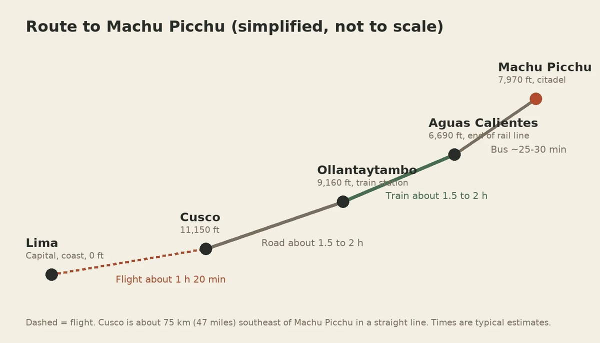
The route map to Machu Picchu runs in stages: a flight from Lima to Cusco, a drive to Ollantaytambo, a train down the Urubamba Valley to Aguas Calientes, then a short bus up to the citadel. Travelers can also board trains near Cusco at Poroy or San Pedro. There is no direct road or flight to the site.
The map shows why the trip feels long even though Cusco looks close: the train follows the river around the mountains instead of crossing them. Full step-by-step options are in our guide on how to get to Machu Picchu, and the coastal leg in the Lima to Machu Picchu route guide.
The bigger context is explained in our what is Machu Picchu guide.
How Is the Machu Picchu Site Laid Out?
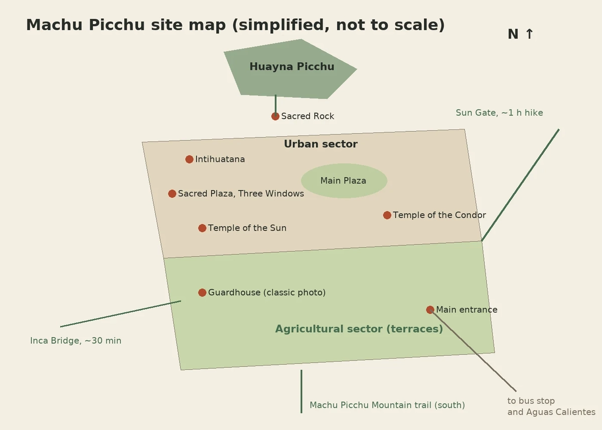
The Machu Picchu site is laid out in two main sectors divided by a long wall and dry moat. The agricultural sector in the south holds stepped terraces and the guardhouse. The urban sector in the north holds temples, plazas, homes and workshops. Huayna Picchu rises at the far northern end, with Machu Picchu Mountain behind the south.
The urban sector is often described in two halves on either side of the Main Plaza: a western upper area with the main religious buildings, and an eastern lower area with homes, storehouses and the Temple of the Condor. Visitors enter at the southern end near the bus stop and walk north through the site.
Where Is Each Landmark on the Machu Picchu Map?
On the Machu Picchu map, the guardhouse and terraces sit at the high southern end, the Temple of the Sun and royal area lie near the center west, the Sacred Plaza and Intihuatana sit on the northwest hill, and the Temple of the Condor is on the east side. The Sacred Rock marks the trail to Huayna Picchu.
Go deeper with our detailed guides: Inca bridge Machu Picchu, Intihuatana stone, Sun Gate Machu Picchu, temple of the Moon Machu Picchu and temple of the Sun Machu Picchu.
| Landmark | Where on the map | What it is |
|---|---|---|
| Guardhouse (Caretaker's Hut) | Upper south, above the terraces | Classic postcard viewpoint |
| Agricultural terraces | South and east slopes | Inca farming platforms |
| Temple of the Sun | Center west, urban sector | Curved tower over a rock cave |
| Sacred Plaza and Temple of Three Windows | Northwest, below the Intihuatana | Main ceremonial square |
| Intihuatana | Hilltop, northwest | Carved ritual stone |
| Main Plaza | Center, between the two halves | Large open lawn |
| Temple of the Condor | East side, lower urban sector | Rock shaped like a condor |
| Sacred Rock | Far north | Gateway to the Huayna Picchu trail |
| Sun Gate (Inti Punku) | Southeast, uphill outside the site | Inca Trail entry point |
| Inca Bridge | West, along a cliff path | Wooden gap in a stone trail |
Which landmarks you see depends on your ticket route; our guide to the Machu Picchu circuits shows what each route includes.
How Do You Read the Official Machu Picchu Circuit Map?
The official Machu Picchu circuit map shows one-way walking routes marked by color and number, starting at the southern entrance and ending at the exit. Each ticket matches one circuit and one route, and guards ask you to keep moving forward. Backtracking is generally not allowed, so plan your photo stops before you reach them.
- Find your circuit number and route code printed on your ticket.
- Locate the entrance at the bottom right of most maps, near the bus stop.
- Follow the colored line for your route through the terraces and urban sector.
- Note where your route meets the upper viewpoint; some routes skip it.
- Check the exit point and the restrooms, which are outside the gate.
The Ministry of Culture publishes current circuit maps on the official Machu Picchu website, and routes can change by season. Ticket choices are explained in our guide to Machu Picchu tickets.
Where Are the Mountains and Hikes on the Map?
On the map, Huayna Picchu is the steep peak at the northern end of the ruins, reached past the Sacred Rock. Machu Picchu Mountain rises to the south, above the entrance and terraces. The Sun Gate trail climbs southeast from the guardhouse, and the Inca Bridge path heads west along a cliff.
Each hike requires its own ticket or route, and none can be added once you are inside. Details are in our guides to the Huayna Picchu hike and the Machu Picchu Mountain climb. Trekking routes such as the Inca Trail arrive from the southeast through the Sun Gate; see the Inca Trail permits guide. To arrive on foot through the Sun Gate with a licensed team, see our 4-day Classic Inca Trail trek.
| Hike | Direction from the ruins | Typical round trip |
|---|---|---|
| Huayna Picchu | North | About 2 to 3 hours |
| Machu Picchu Mountain | South | About 3 to 4 hours |
| Sun Gate (Inti Punku) | Southeast | About 1.5 to 2 hours |
| Inca Bridge | West | About 30 to 45 minutes |
Hiking times are typical estimates and depend on fitness, crowds and the weather.
Can You Use Google Maps or a PDF Map at Machu Picchu?
Google Maps shows Machu Picchu, Aguas Calientes and the bus road, but it gives little detail inside the ruins and mobile signal at the site is weak. Download an offline map of the area before you go. Paper maps are not always handed out at the gate, so save the official circuit map image on your phone.
Alongside this Machu Picchu Map guide, you can also compare all our Machu Picchu tours side by side, from one-day visits to multi-day treks.
- Download offline Google Maps for Cusco and the Urubamba Valley.
- Save a photo of the official circuit map for your route.
- Screenshot your ticket, train and bus details in case there is no signal.
- Ask your guide to point out landmarks against your map at the start.
- Use the map to plan restroom breaks, since toilets are outside the entrance.
Frequently asked questions
Is Machu Picchu in the Amazon?
Machu Picchu is not in the Amazon itself, but it sits on the eastern slope of the Andes where the mountains begin to meet the rainforest. The surrounding cloud forest is lush and humid. The Urubamba River below eventually flows into the Amazon basin.
How far is Machu Picchu from Cusco on a map?
On a map, Machu Picchu is about 47 miles (75 km) northwest of Cusco in a straight line. The actual journey is longer, because trains follow the Urubamba Valley. Most trips from Cusco to the citadel take about 4 to 5 hours each way.
What are the coordinates of Machu Picchu?
The coordinates of Machu Picchu are approximately 13.16° S latitude and 72.55° W longitude. That places the citadel in the southern hemisphere, in the same general time zone as the US Eastern zone outside daylight saving time. Peru does not change its clocks.
Which side of the map is Huayna Picchu?
Huayna Picchu is on the northern side of the Machu Picchu map, directly behind the ruins in classic photos. Machu Picchu Mountain is the opposite, larger peak to the south. Most famous postcard photos are taken from the south looking north toward Huayna Picchu.
Is there a map at the entrance of Machu Picchu?
There are information boards near the entrance, but visitors should not count on receiving a printed map. Signs along the paths mark routes and directions. Saving the official circuit map on your phone before arrival is the most reliable option.
Is Machu Picchu close to Lake Titicaca?
Machu Picchu is not close to Lake Titicaca on the map. The lake lies roughly 250 miles (400 km) to the southeast near the Bolivian border. Travelers usually connect them through Cusco by bus, train or flight over a full day.
Where are the Royal Tomb and the fountains on the Machu Picchu map?
The Royal Tomb is the carved cave directly beneath the Temple of the Sun in the urban sector. Beside it, a chain of 16 stone fountains runs downhill in a staircase, fed by an Inca canal from the mountain. Both sit along the classic Circuit 2 routes near the middle of the site.
Want a route planned around your map?
Tell us your dates and the landmarks or hikes you want to see, and we will match the right ticket route, train and guide. Prefer to read first? Get the free Machu Picchu trip guide.
Sources checked October 3, 2026
Recommended tours
Packages · 7 days
Machu Picchu Vacation Packages, 3, 5 and 7 Days
3, 5 or 7 days from Cusco with hotels, trains, Machu Picchu tickets and guides arranged. From $479.
from $1290
View tour →
Inca Trail · 4 days
Classic Inca Trail to Machu Picchu, 4 Days
The world-famous 43 km trek on original Inca stone paths, ending at the Sun Gate.
from $827
View tour →Keep planning
- Machu Picchu Tickets 2026: Prices, Ticket Types and How to Buy
- Best Time to Visit Machu Picchu: Best Months, Seasons and Time of Day
- How to Get to Machu Picchu: Every Route From Cusco Compared
- Machu Picchu Hotels: Best Places to Stay Near the Citadel by Area and Budget
- Machu Picchu Cost Breakdown: How Much It Costs to Go in 2026
- Machu Picchu Rules and Regulations: The Complete 2026 Visitor Code
- Machu Picchu in December: Is a Rainy-Season Holiday Visit Worth It?
- Machu Picchu With Kids: How to Plan a Family Visit at Any Age